Posts

Label In ARCGIS

Image
I want to display the label after a character in ArcGIS desktop Function FindLabel ( [LABEL]  ) la = InStr([LABEL],"-") lab=len([LABEL])-la FindLabel = Right([LABEL],lab) End Function here i have used the two variable - "la"& "lab" Ex:- My Label field having ABC-25367. I want to display 25367 la variable will store the 4th position means value will be 4 lab = (length  of label (9)-la(4)) = 5 Using Right expression, It will display the 5 right side characters (25367)
ARCGIS 10.1 Tutorial Data

ArcGIS 10.1 Tutorial data available at http://www.esri.com/apps/products/arcgis/v10_1/eval/demomktg/index.cfm?event=download.index&ESRISessionID=OcjV69sjTzCLMnSHSGXUKUFXCb6d9-DJozb3nKNxDhbypxNu7i_MY_xGCQAlPHWp0nAxTY0= Enter the account through the ESRI global account.

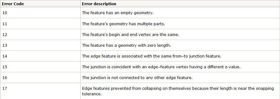
Net Build Error - Type of errors

Image

ORA-00001;unique constraint error

Image
If you get above - ORA-00001;unique constraint error R****_sde_ROWID_UK violated connect the sde server and get the ROWID numbers using below statements. Please enter one by one relationship with having table and match the number with error number. That relationship having the duplicate indexid (RID field). example sdetable -o describe_reg -t MJEC.SupportStructure_Fuse -u sde -p sde answer 418 sdetable -o describe_reg -t MJEC.SupportStructure_Switch -u sde -p sde answer 426 sdetable -o describe_reg -t MJEC.SupptStruct_MiscNetworkFeat -u sde -p sde answer 422 sdetable -o describe_reg -t MJEC.SupptStruct_PFCorrectEquip -u sde -p sde answer 424 sdetable -o describe_reg -t MJEC.SupptStruct_Streetlight -u sde -p sde answer 423 sdetable -o describe_reg -t MJEC.SupptStruct_Transformer -u sde -p sde answer 416 sdetable -o describe_reg -t MJEC.SupptStruct_VoltBoostTrans -u sde -p sde answer 425 Snapshot sh...

Arc FM sample data

ArcFM sample data available at  http://www.telvent-gis.com/support/installers.html Under every product given the sample data links. Like Minerville data bases

Create Blank/Empty MXD with Same Symbology

Image
Create an Empty MXD in ArcGIS 10 with same symbology from previously used for accessing data . Follow the below steps. 1. Open the ArcCatalog -> Go to the MXD ( Which you want create blank from the Existing MXD)  Right click and select the Set Data Source 2. In the above snap shot you can identify Output File - It changes the name of "Copy of" and then click a Select all option next click Replace button then Replace with button make it as Null (Remove the path). Then it will create a new MXD with a Copy of name.Please check the below snap shot

SDE Lineages count and some commands

Connect as sde login in your database through Sql sql> SELECT COUNT(*) FROM sde.state_lineages WHERE lineage_name NOT IN (SELECT DISTINCT lineage_name FROM sde.states); Versions names and State_ID SELECT name, state_id FROM sde.versions; States count SELECT COUNT(*) FROM sde.states;